| [T84997] | Pieter van den Keere (printmaker), Germaniae veteris nova decriptio. In Accuratissima orbis antiqui delineatio, Amsterdam: Johannes Janssonius (printer), 1653 (Zürich, ZB) ◼ | printing: impression | page: figure | | paper | book decoration: illustration | 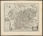 | | | | | | |
| [T84969] | Philipp Clüver (designer), Map of Germania. In Gaius Iulius Caesar, The commentaries of Caesar, William Duncan (translator), London: Jacob (III) Tonson and Richard (II) Tonson (printer), 1753, no 20 | printing: impression | page: figure | | paper | book decoration: illustration | | | | | | | |
| [T84775] | Philipp Clüver (designer), Nicolaas van Geilenkercken (printmaker), Map of Germania Cisrhenana. In Philipp Clüver, Germaniae antiquae libri tres ... Adjectae sunt Vindelicia et Noricum, Leiden: Lowijs (I) Elzevier (printer), Officina Elzeviriana (printer), 1616 (London, Wellcome Collection) ◼ | printing: impression | page: figure | | paper | book decoration: illustration | 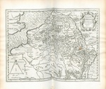 | | | | | | |
| [T84777] | Philipp Clüver (designer), Nicolaas van Geilenkercken (printmaker), Maps of Territories of Inhabitants of the Scheldt, Meuse, and Rhine (Scaldis, Mosae ac Rheni ostiorum, gentiumque accolarum antiqua descriptio). In Philipp Clüver, Germaniae antiquae libri tres ... Adjectae sunt Vindelicia et Noricum, Leiden: Lowijs (I) Elzevier (printer), Officina Elzeviriana (printer), 1616 (London, Wellcome Collection) | printing: impression | page: figure | | paper | book decoration: illustration | | | | | | | |
| [T84780] | Philipp Clüver (designer), Nicolaas van Geilenkercken (printmaker), Map of Germanic Territories from Trajan's Reign. In Philipp Clüver, Germaniae antiquae libri tres ... Adjectae sunt Vindelicia et Noricum, Leiden: Lowijs (I) Elzevier (printer), Officina Elzeviriana (printer), 1616 (London, Wellcome Collection) | printing: impression | page: figure | | paper | book decoration: illustration | | | | | | | |
| [T84779] | Philipp Clüver (designer), Nicolaas van Geilenkercken (printmaker), Map of Germanic Territories between Caesar's and Trajan's Reigns. In Philipp Clüver, Germaniae antiquae libri tres ... Adjectae sunt Vindelicia et Noricum, Leiden: Lowijs (I) Elzevier (printer), Officina Elzeviriana (printer), 1616 (London, Wellcome Collection) | printing: impression | page: figure | | paper | book decoration: illustration | | | | | | | |
| [T84491] | Philipp Clüver (designer), Map of Germania. In Gaius Iulius Caesar, C. Julii Caesaris quae extant, London: Jacob (I) Tonson (printer), 1712 (San Fernando, Real Instituto y Observatorio de la Armada), no 20 ◼ | printing: impression | page: figure | | paper | book decoration: illustration | 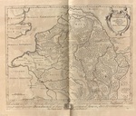 | | | | | | |
| [T57493] | [wanting: Map of Germany]. In Johannes Honter, Rvdimentorvm cosmographicorvm Ioan. Honteri Coronensis libri III cum tabellis geographicis elegantissimis, Brașov: 1542 (Charlottesville, VA, University of Virginia Library) | printing: impression | page: figure | woodcut | paper | book decoration: illustration | | | | | | | |
| [T56895] | Map of Germany. In Johannes Honter, Rvdimentorvm cosmographicorvm Ioan. Honteri Coronensis libri III cum tabellis geographicis elegantissimis, Brașov: 1542 (Vienna, ÖNB) ◼ | printing: impression | page: figure | woodcut | paper | book decoration: illustration | 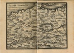 | | | | | | |
| [T6530] | Livio Sanuto (designer), Giulio Sanuto (printmaker), Tabula Europae IIII. In Claudius Ptolemaeus, La Geografia Di Clavdio Tolomeo Alessandrino ..., Girolamo Ruscelli (translator), Venice: Vincenzo Valgrisi (printer), 1561 (Rome, BNCR) ◼ | printing: impression | page: figure | engraving | paper | book decoration: illustration | 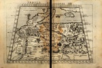 | | | | | | |
| [T16914] | Livio Sanuto (designer), Giulio Sanuto (printmaker), Tabula Europae IIII (Warsaw, BN) ◼ | printing: impression | extracted piece | engraving, hand colouring | paper | |  | | | | 1598 ‑ 1599 | 1598‑01‑01 | 1599‑12‑31 |
| [T56863] | Map of Germany. In Johannes Honter, Rvdimentorvm cosmographicorvm Ioan. Honteri Coronensis libri III cum tabellis geographicis elegantissimis, Zürich: Christoph Froschauer (printer), 1548 (Zürich, ZB) ◼ | printing: impression | page: figure | woodcut | paper | book decoration: illustration |  | | | | | | |
| [T56783] | Map of Germany. In Johannes Stumpf, Gemeiner loblicher Eydgnoschafft Stetten, Landen und Völckeren Chronick wirdiger Thaaten Beschreybung [part 1], Zürich: Christoph Froschauer (printer), 1548 (Zürich, ZB) ◼ | printing: impression | page: figure | woodcut | paper | book decoration: illustration |  | | | | | | |
| [T22645] | Gerard Mercator (printmaker), Europae IIII Tabula. In Claudius Ptolemaeus, Geographiae Libri Octo, Cologne: Gottfried von Kempen (printer), 1584 (Regensburg, Staatliche Bibliothek) ◼ | printing: impression | page: figure | engraving | paper | book decoration: illustration | 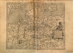 | | | | | | |
| [T28042] | Livio Sanuto (designer), Giulio Sanuto (printmaker), Tabula Europae IIII. In Claudius Ptolemaeus, La geografia Di Clavdio Tolomeo Alessandrino ..., Girolamo Ruscelli (translator), Venice: Giordano Ziletti (printer), 1574 (Boston, MS, Boston Public Library) ◼ | printing: impression | page: figure | engraving | paper | book decoration: illustration | 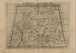 | | | | | | |
| [T28040] | Livio Sanuto (designer), Giulio Sanuto (printmaker), Tabula Europae IIII. In Claudius Ptolemaeus, Geografia Di Clavdio Tolomeo Alessandrino ..., Girolamo Ruscelli (translator), Venice: Heirs of Melchior Sessa (printer), 1599 (Paris, BnF) ◼ | printing: impression | page: figure | engraving | paper | book decoration: illustration | 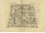 | | | | | | |
| [T28044] | Livio Sanuto (designer), Giulio Sanuto (printmaker), Tabula Europae IIII. In Claudius Ptolemaeus, La Geografia Di Clavdio Tolomeo Alessandrino ..., Girolamo Ruscelli (translator), Venice: Giordano Ziletti (printer), 1564 (Madrid, Universidad Complutense de Madrid) ◼ | printing: impression | page: figure | engraving | paper | book decoration: illustration | 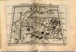 | | | | | | |
| [T22649] | Gerard Mercator (printmaker), Europae IIII Tabula. In Claudius Ptolemaeus, Cl[audii] Ptolemaei Alexandrini Geographiae Libri Octo ..., Cologne: Gottfried von Kempen (printer), 1584 (Stanford, CA, Stanford University Libraries) | printing: impression | page: figure | engraving | paper | book decoration: illustration | | | | | | | |
| [T6526] | Giacomo Gastaldi (designer), Tabula Europae IIII. In Claudius Ptolemaeus, Ptolemeo La Geografia Di Clavdio Ptolemeo Alessandrino ..., Pietro Andrea Mattioli (translator), Venice: Giovanni Battista Pedrezano (printer), 1548 (Rome, BNCR) ◼ | printing: impression | page: figure | engraving | paper | book decoration: illustration | 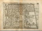 | | | | | | |
| [T6492] | Sebastian Münster (designer), Conrad Schnitt (printmaker), Tabula Europae IIII. In Geographia Vniversalis Vetvs Et Nova ... Addita sunt insuper Scholia ... Succedunt tabulae Ptolemaic[a]e... opera Sebastiani Munsteri ..., Sebastian Münster (compiler), Basel: Heinrich Petri (printer), 1540 (Toruń, Biblioteka Uniwersytecka) ◼ | printing: impression | page: figure | woodcut | paper | book decoration: illustration | 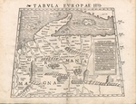 | | | | | | |
