| [T84760] | Philipp Clüver (designer), Nicolaas van Geilenkercken (printmaker), Map od Ancient Europe (Summa Europae Antiquae). In Philipp Clüver, Germaniae antiquae libri tres ... Adjectae sunt Vindelicia et Noricum, Leiden: Lowijs Elzevier (printer), 1616 (London, Wellcome Collection) | printing: impression | page: figure | | paper | book decoration: illustration | | | | | | | |
| [T84759] | Philipp Clüver (designer), Nicolaas van Geilenkercken (printmaker attr.), Map of Northern Europe and Asia (Septemtrionalium Europa et Asia terrarum descriptio). In Philipp Clüver, Germaniae antiquae libri tres ... Adjectae sunt Vindelicia et Noricum, Leiden: Lowijs Elzevier (printer), 1616 (London, Wellcome Collection) ◼ | printing: impression | page: figure | | paper | book decoration: illustration | 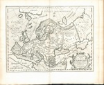 | | | | | | |
| [T84775] | Philipp Clüver (designer), Nicolaas van Geilenkercken (printmaker), Map of Germania Cisrhenana. In Philipp Clüver, Germaniae antiquae libri tres ... Adjectae sunt Vindelicia et Noricum, Leiden: Lowijs Elzevier (printer), 1616 (London, Wellcome Collection) | printing: impression | page: figure | | paper | book decoration: illustration | | | | | | | |
| [T84776] | Philipp Clüver (designer), Nicolaas van Geilenkercken (printmaker), Map of Helvetia. In Philipp Clüver, Germaniae antiquae libri tres ... Adjectae sunt Vindelicia et Noricum, Leiden: Lowijs Elzevier (printer), 1616 (London, Wellcome Collection) | printing: impression | page: figure | | paper | book decoration: illustration | | | | | | | |
| [T84777] | Philipp Clüver (designer), Nicolaas van Geilenkercken (printmaker), Maps of Territories of Inhabitants of the Scheldt, Meuse, and Rhine (Scaldis, Mosae ac Rheni ostiorum, gentiumque accolarum antiqua descriptio). In Philipp Clüver, Germaniae antiquae libri tres ... Adjectae sunt Vindelicia et Noricum, Leiden: Lowijs Elzevier (printer), 1616 (London, Wellcome Collection) | printing: impression | page: figure | | paper | book decoration: illustration | | | | | | | |
| [T84780] | Philipp Clüver (designer), Nicolaas van Geilenkercken (printmaker), Map of Germanic Territories from Trajan's Reign. In Philipp Clüver, Germaniae antiquae libri tres ... Adjectae sunt Vindelicia et Noricum, Leiden: Lowijs Elzevier (printer), 1616 (London, Wellcome Collection) | printing: impression | page: figure | | paper | book decoration: illustration | | | | | | | |
| [T84779] | Philipp Clüver (designer), Nicolaas van Geilenkercken (printmaker), Map of Germanic Territories between Caesar's and Trajan's Reigns. In Philipp Clüver, Germaniae antiquae libri tres ... Adjectae sunt Vindelicia et Noricum, Leiden: Lowijs Elzevier (printer), 1616 (London, Wellcome Collection) | printing: impression | page: figure | | paper | book decoration: illustration | | | | | | | |
| [T84491] | Map of Germania. In Gaius Iulius Caesar, C. Julii Caesaris quae extant, London: Jacob (I) Tonson (printer), 1712 (San Fernando, Real Instituto y Observatorio de la Armada), no 20 ◼ | printing: impression | page: figure | | paper | book decoration: illustration | 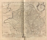 | | | | | | |
| [T84388] | Map of Gaul. In Gaius Iulius Caesar, C. Julii Caesaris quae extant, London: Jacob (I) Tonson (printer), 1712 (San Fernando, Real Instituto y Observatorio de la Armada), after ad lectorem, no 4 ◼ | printing: impression | page: figure | | paper | book decoration: illustration | 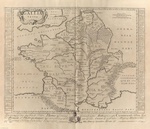 | | | | | | |
| [T84630] | Map of Hispania. In Gaius Iulius Caesar, C. Julii Caesaris quae extant, London: Jacob (I) Tonson (printer), 1712 (San Fernando, Real Instituto y Observatorio de la Armada), no 78 ◼ | printing: impression | page: figure | | paper | book decoration: illustration | 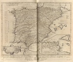 | | | | | | |
| [T84556] | Abraham Ortelius (designer), Map of Hispania. In Gaius Iulius Caesar, C. Ivlii Caesaris Omnia Qvae Exstant, Leiden: Franciscus (I) Raphelengius (printer), Officina Plantiniana (printer), 1593 (Prague, NK ČR) ◼ | printing: impression | page: figure | | paper | book decoration: illustration | 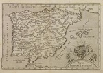 | | | | | | |
| [T84555] | Map of Gaul. In Gaius Iulius Caesar, C. Ivlii Caesaris Omnia Qvae Exstant, Leiden: Franciscus (I) Raphelengius (printer), Officina Plantiniana (printer), 1593 (Prague, NK ČR) ◼ | printing: impression | page: figure | | paper | book decoration: illustration | 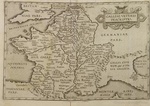 | | | | | | |
| [T84369] | Map of Hispania. In I commentari di C. Giulio Cesare : con le figure in rame, Venice: Pietro de' Franceschi (printer), 1575 ◼ | printing: impression | page: figure | | paper | book decoration: illustration | 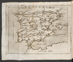 | | | | | | |
| [T84368] | Map of Gaul. In I commentari di C. Giulio Cesare : con le figure in rame, Venice: Pietro de' Franceschi (printer), 1575 ◼ | printing: impression | page: figure | | paper | book decoration: illustration | 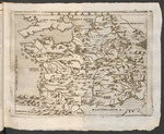 | | | | | | |
| [T84158] | Map of Hispania. In I commentari. Con figure, e tavole delle materie e de i nomi delle citta, ch'in questi commentari si leggono, antichi e moderni, per adietro non piu stampate, Venice: Gabriele Giolito (printer), 1557 (Lyon, Bibliothèque municipale de Lyon) ◼ | printing: impression | page: figure | woodcut | paper | book decoration: illustration | 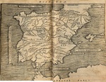 | | | | | | |
| [T84159] | Map of Gaul. In I commentari. Con figure, e tavole delle materie e de i nomi delle citta, ch'in questi commentari si leggono, antichi e moderni, per adietro non piu stampate, Venice: Gabriele Giolito (printer), 1557 (Lyon, Bibliothèque municipale de Lyon) ◼ | printing: impression | page: figure | woodcut | paper | book decoration: illustration | 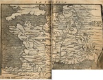 | | | | | | |
| [T76479] | Antonio Lafreri (print publisher), Carta marina (Washington, DC, Library of Congress) ◼ | printing: impression | single piece | woodcut, hand colouring | paper | map |  | | | | 1572 | 1572‑01‑01 | 1572‑12‑31 |
| [T76479] | Antonio Lafreri (print publisher), Carta marina (Washington, DC, Library of Congress) ◼ | printing: impression | single piece | woodcut, hand colouring | paper | map | | | | | 1572 | 1572‑01‑01 | 1572‑12‑31 |
| [T76479] | Antonio Lafreri (print publisher), Carta marina (Washington, DC, Library of Congress) ◼ | printing: impression | single piece | woodcut, hand colouring | paper | map | | | | | 1572 | 1572‑01‑01 | 1572‑12‑31 |
| [T16833] | Antonio Lafreri (print publisher), Carta marina (Stockholm, KB) ◼ | printing: impression | single piece | engraving, hand colouring, etching | paper | map | 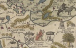 | | | | 1572 | 1572‑01‑01 | 1572‑12‑31 |
